How GPS Speedometers Work: The Science Behind Accuracy
Learn the technology behind GPS speed tracking, from satellite signals to Doppler calculations, and why GPS provides accurate speed measurements.
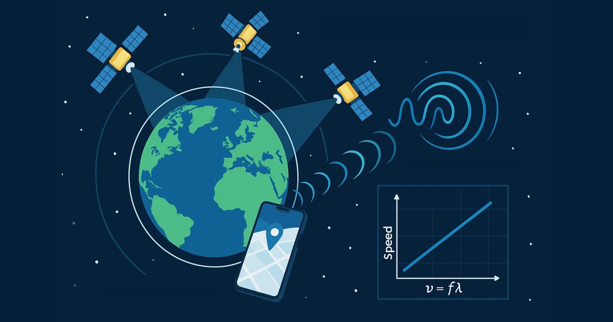
Table of Contents
Introduction
Every day, millions of people rely on GPS speedometers in their phones and vehicles without understanding the remarkable technology making it possible. GPS speed tracking seems almost magical—invisible satellites thousands of miles away somehow know exactly how fast you’re moving down to a fraction of a mile per hour. But there’s no magic involved, just brilliant engineering and fundamental physics.
In this comprehensive guide, you’ll discover how GPS speedometers actually work, from satellite orbital mechanics to the mathematical algorithms converting radio signals into precise velocity measurements. Understanding this technology helps you use GPS speed tracking more effectively, troubleshoot accuracy issues, and appreciate one of humanity’s most impressive technological achievements.
Key Takeaways
- GPS uses 24-32 satellites orbiting Earth at 12,550 miles altitude
- Speed calculation requires 4+ satellites for triangulation and timing
- Doppler shift provides direct velocity measurement independent of position accuracy
- Update rates of 1-10 Hz provide continuous speed monitoring
- No internet required - GPS receivers are passive listening devices
- Accuracy within 0.2 mph achievable under optimal conditions
- Works worldwide with same satellites providing global coverage
Understanding GPS: The Global Positioning System
What GPS Actually Means
GPS stands for Global Positioning System, a satellite-based navigation system originally developed by the U.S. Department of Defense for military applications. Fully operational since 1995 and opened for civilian use, GPS has become essential infrastructure for navigation, timing, and speed measurement worldwide.
GPS system components:
Space segment:
- 24-32 active satellites
- Orbital altitude: 12,550 miles (20,200 km)
- Orbital period: 11 hours 58 minutes
- 6 orbital planes at 55° inclination
- Each satellite visible for 4-6 hours
Control segment:
- Master Control Station (Schriever Air Force Base, Colorado)
- 16 monitoring stations worldwide
- 4 ground antenna stations
- Continuous satellite health monitoring
- Orbit and clock error correction
User segment:
- GPS receivers (phones, cars, dedicated devices)
- Passive listening-only operation
- No transmission required
- Unlimited simultaneous users
This three-part architecture ensures reliable global coverage with multiple satellites visible from any point on Earth at any time.
How GPS Satellites Work
GPS satellites are precision timekeeping machines orbiting Earth, each carrying atomic clocks accurate to nanoseconds. These satellites continuously broadcast their position and precise time stamps, allowing receivers to calculate location and velocity.
Satellite capabilities:
- 4 atomic clocks per satellite (2 cesium, 2 rubidium)
- Solar panels generating 700+ watts
- Designed lifespan: 10-15 years
- Signal power reaching Earth: -160 dBW (extremely weak)
- Broadcast frequency: L1 (1575.42 MHz) and L2 (1227.60 MHz)
Signal content:
- Satellite identification
- Current satellite position (ephemeris data)
- Constellation health information (almanac data)
- Precise transmission timestamp
- Correction parameters
Each satellite transmits continuously, and your GPS receiver listens passively to these broadcasts—GPS is entirely one-way communication from satellites to your device.
The GPS Signal Journey
Understanding how GPS signals travel from space to your receiver reveals why GPS works so well and what can interfere with accuracy.
Signal transmission:
- Satellite generates coded signal with timestamp
- Signal travels at speed of light (186,282 miles/second)
- Earth’s atmosphere delays signal slightly (ionosphere, troposphere)
- Signal arrives at receiver with 20,000+ mile journey completed in ~0.067 seconds
- Receiver decodes signal and extracts timestamp
Signal characteristics:
- Extremely weak by arrival (less power than a 60W light bulb 1,000 miles away)
- Uses spread-spectrum technology for noise resistance
- Civilian L1 signal available to anyone
- Military encrypted P(Y) code for enhanced accuracy
Your phone’s GPS chip amplifies these incredibly faint signals and extracts the timing information critical for position and speed calculations.
How GPS Calculates Your Position
Before understanding GPS speed measurement, you need to grasp how GPS determines position—speed calculation builds upon this foundation.
The Trilateration Principle
GPS determines your position using a mathematical technique called trilateration (often incorrectly called “triangulation”). By measuring distance from multiple satellites with known positions, your receiver calculates where you must be located.
Basic concept:
With 1 satellite:
- Know distance to satellite
- Your position is somewhere on a sphere around that satellite
- Infinite possible locations
With 2 satellites:
- Know distance to two satellites
- Your position is on the circle where two spheres intersect
- Still many possible locations
With 3 satellites:
- Know distance to three satellites
- Your position is at one of two points where three spheres intersect
- One point is in space, one on Earth (easy to eliminate)
With 4 satellites:
- Resolves timing ambiguity in receiver clock
- Provides 3D position (latitude, longitude, altitude)
- Eliminates both intersection points problem
Why 4 satellites minimum:
GPS receivers don’t have atomic clocks—they use inexpensive quartz clocks that drift. The 4th satellite measurement solves for receiver clock error simultaneously with position. This clever mathematical trick eliminates the need for expensive atomic clocks in every GPS device.
Distance Measurement Through Time
GPS measures distance by precisely timing how long signals take to travel from satellites to your receiver.
Distance calculation:
Speed of light × Travel time = Distance
Example:
- Signal travel time: 0.067 seconds
- Speed of light: 186,282 miles/second
- Distance to satellite: 12,481 miles
Precision required:
GPS timing must be incredibly accurate because errors multiply quickly:
- 1 microsecond (0.000001 sec) error = 984 feet position error
- 1 nanosecond (0.000000001 sec) error = 1 foot position error
This is why satellites carry atomic clocks accurate to billionths of a second.
The Role of Atomic Clocks
Satellite atomic clocks maintain time with extraordinary precision, losing only 1 second every 300,000 years. This precision is essential for accurate distance measurement.
How atomic clocks work:
- Measure natural resonance frequency of cesium or rubidium atoms
- Cesium-133 atoms transition at exactly 9,192,631,770 Hz
- This frequency defines the SI second by international agreement
- Electronic circuits count these transitions to keep perfect time
Why accuracy matters:
If satellite clocks were off by just 1 millisecond:
- Position error: 186 miles
- Speed error: Completely useless
- System would be worse than map and compass
Ground control stations constantly monitor and correct satellite clocks, uploading adjustment data that receivers apply to calculations.
How GPS Measures Speed: Two Methods
GPS receivers actually use two distinct methods to determine your speed—position-based calculation and Doppler shift measurement. Understanding both reveals why GPS speed accuracy exceeds position accuracy.
Method 1: Position-Based Speed Calculation
The most intuitive speed calculation method: measure position changes over time and divide distance by elapsed time.
Process:
- Record Position 1: Latitude, longitude at time T1
- Record Position 2: Latitude, longitude at time T2
- Calculate Distance: Haversine formula for curved Earth
- Calculate Time Elapsed: T2 - T1
- Compute Speed: Distance ÷ Time
Example:
Position 1: 40.7128° N, 74.0060° W at 12:00:00.00 Position 2: 40.7129° N, 74.0059° W at 12:00:01.00
Distance moved: 45.3 meters Time elapsed: 1.00 seconds Speed: 45.3 m/s = 101 mph
Update rate effects:
1 Hz GPS (1 position/second):
- Compares positions 1 second apart
- Smooth speed reading
- Slight lag during acceleration
- Adequate for most driving
5 Hz GPS (5 positions/second):
- Compares positions 0.2 seconds apart
- More responsive to changes
- Better during acceleration/deceleration
- Preferred for performance tracking
10 Hz GPS (10 positions/second):
- Compares positions 0.1 seconds apart
- Very responsive
- Professional grade performance
- Higher power consumption
Limitations:
Position-based speed calculation inherits all position accuracy limitations. If position has ±10 meter error, speed calculations amplify this noise, causing momentary fluctuations.
Method 2: Doppler Shift Direct Measurement
The more sophisticated and accurate method exploits the Doppler effect—the frequency shift that occurs when GPS satellites move relative to your receiver.
The Doppler effect explained:
You’ve experienced Doppler shift with sound: an ambulance siren sounds higher-pitched approaching and lower-pitched moving away. The same effect occurs with radio waves.
GPS Doppler shift:
Satellite moving toward you:
- Received frequency increases slightly
- Compressed wavelengths
- Positive Doppler shift
Satellite moving away from you:
- Received frequency decreases slightly
- Stretched wavelengths
- Negative Doppler shift
Satellite at 90° angle (perpendicular motion):
- No frequency change
- Zero Doppler shift
- Maximum occurs at 0° or 180°
Speed calculation from Doppler:
The magnitude of frequency shift directly indicates relative velocity between satellite and receiver. Since satellite velocity is precisely known, your velocity can be calculated.
Formula:
Δf / f = v / c
Where:
- Δf = frequency shift (measured)
- f = transmitted frequency (known)
- v = velocity (calculated)
- c = speed of light (constant)
Example:
Transmitted frequency: 1575.42 MHz Measured frequency: 1575.42005 MHz Frequency shift: +5 Hz Calculated velocity: 0.952 m/s toward satellite
By combining Doppler measurements from multiple satellites with different motion vectors, your receiver calculates your 3D velocity (speed and direction).
Why Doppler is more accurate than position:
- Direct measurement of velocity, not derived from position
- Less susceptible to multipath errors
- No accumulation of position errors
- Smooth measurements even with position noise
- Update rate matches signal processing (can be >10 Hz)
Modern GPS receivers use both methods: Doppler for primary speed accuracy, position-based for verification and initialization.
Factors Affecting GPS Speed Accuracy
While GPS provides excellent speed accuracy overall, understanding what affects performance helps optimize usage and interpret readings correctly.
Satellite Geometry and HDOP
The geometric arrangement of satellites significantly impacts accuracy. Optimal geometry occurs when satellites are widely spaced in the sky, while poor geometry happens when satellites cluster together.
HDOP: Horizontal Dilution of Precision
HDOP quantifies geometric quality:
- HDOP < 2: Excellent geometry (±5 meter accuracy)
- HDOP 2-5: Good geometry (±10 meter accuracy)
- HDOP 5-10: Moderate geometry (±25 meter accuracy)
- HDOP > 10: Poor geometry (±50+ meter accuracy)
Why geometry matters:
Imagine determining your position using four points:
Good geometry:
- Satellites at North, South, East, and West
- Large angular separation
- Small HDOP
- Precise position calculation
Poor geometry:
- All four satellites clustered in southern sky
- Small angular separation
- Large HDOP
- Imprecise position calculation
GPS receivers display satellite constellation in real-time. Apps often show satellite count and HDOP—higher satellite count with low HDOP indicates optimal conditions.
Speed impact:
Speed calculations are less sensitive to HDOP than position because Doppler measurements provide direct velocity information. You might have ±20 meter position accuracy but still achieve ±0.2 mph speed accuracy.
Atmospheric Effects
GPS signals travel through Earth’s atmosphere, which delays and slightly distorts them. Receivers apply corrections, but residual errors remain.
Ionosphere:
60-600 miles altitude, charged particle layer
- Varies with solar activity
- Greater delay during day than night
- More effect at lower elevations
- Correction models reduce error by 50-60%
Ionospheric delay impact:
- Position error: 5-10 meters (uncorrected)
- Position error: 2-4 meters (corrected)
- Speed error: Minimal (cancels out in Doppler)
Troposphere:
0-10 miles altitude, weather layer
- Water vapor causes delay
- Varies with temperature and pressure
- More effect at lower elevations
- Difficult to model precisely
Tropospheric delay impact:
- Position error: 2-5 meters
- Speed error: <0.1 mph (negligible)
Why speed is less affected:
Atmospheric delays affect all position measurements similarly within short time periods. When calculating speed from position changes, atmospheric errors largely cancel out. Doppler velocity measurements are even less susceptible.
Multipath Interference
Multipath occurs when GPS signals reflect off buildings, terrain, or vehicles before reaching your receiver. The receiver sees both direct and reflected signals, causing position errors.
Multipath scenarios:
Urban canyon:
- Tall buildings on both sides
- Signals bounce multiple times
- Receiver receives direct + 2-3 reflected signals
- Position errors of 10-50 meters possible
Near large structures:
- Parking near mall, stadium, or warehouse
- One or two strong reflections
- Position errors of 5-20 meters
Open highway:
- Minimal nearby reflectors
- Primarily direct signals
- Position errors <5 meters
Multipath effects on speed:
Position-based speed:
- Inherits position errors
- May show ±2-5 mph fluctuations in urban areas
- Smoothing algorithms help
Doppler-based speed:
- Much less affected by multipath
- Reflected signals have different Doppler shifts
- Receiver can often distinguish and reject
- Maintains ±0.5 mph accuracy even with multipath
This is why GPS speed remains relatively stable even when position “jumps around” on a map in urban environments.
Device Quality and Chipset
Not all GPS receivers are created equal. Chipset quality dramatically affects performance.
Consumer GPS chipsets:
Budget tier (<$5 chipsets):
- Single-frequency (L1 only)
- 1 Hz update rate
- Basic satellite tracking
- Position accuracy: ±10 meters
- Speed accuracy: ±0.5 mph
Mid-tier ($5-15 chipsets):
- Single-frequency (L1)
- 1-5 Hz update rate
- Better satellite tracking algorithms
- Position accuracy: ±5 meters
- Speed accuracy: ±0.2 mph
High-tier ($15-50 chipsets):
- Dual-frequency (L1 + L5 or L1 + L2)
- 5-10 Hz update rate
- Advanced multipath rejection
- Position accuracy: ±2 meters
- Speed accuracy: ±0.1 mph
Smartphone GPS:
iPhone:
- iPhone 12 and newer: Dual-frequency (L1 + L5)
- iPhone 11 and older: Single-frequency (L1)
- Update rate: Typically 1-5 Hz
- Excellent signal processing algorithms
- Speed accuracy: ±0.1-0.2 mph
Android flagship phones:
- Most 2020+ flagships: Dual-frequency
- Update rate: 1-5 Hz (varies by model)
- Quality varies by manufacturer
- Speed accuracy: ±0.2-0.3 mph
Android budget phones:
- Often single-frequency
- Lower update rates
- Basic chipsets
- Speed accuracy: ±0.5-1 mph
Dual-frequency advantages:
Modern dual-frequency receivers use two GPS signal frequencies simultaneously (L1 + L5 or L1 + L2), dramatically improving accuracy especially in challenging environments.
Benefits:
- Ionospheric error nearly eliminated
- Better multipath rejection
- Improved accuracy in urban areas
- Position accuracy: 2-3x better
- Speed accuracy: Slightly improved
If buying a new phone or GPS device, dual-frequency is worth prioritizing for optimal performance.
GPS Speed Accuracy in Real-World Conditions
Open Highway Performance
GPS delivers peak performance on open roads with clear sky visibility.
Optimal conditions:
- 8-12 satellites visible
- HDOP < 2
- Minimal multipath
- Clear atmospheric conditions
Expected accuracy:
- Position: ±2-5 meters
- Speed: ±0.1 mph (±0.16 km/h)
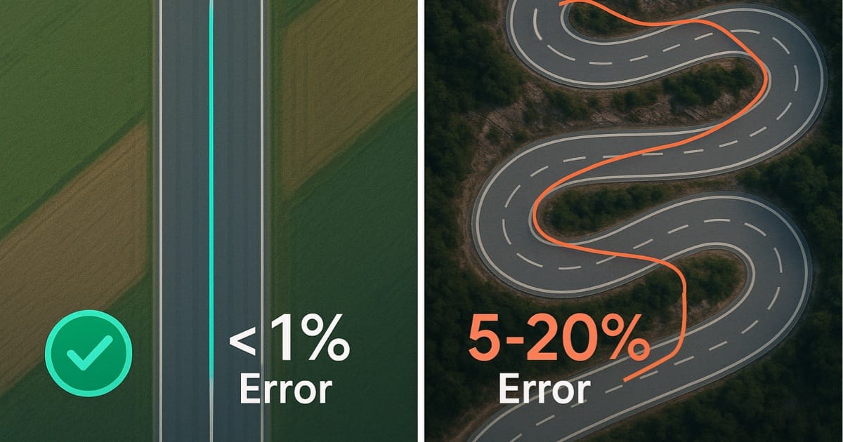
- Speed error percentage: <1% at highway speeds
Real-world highway test:
True speed (verified by mile markers): 60.0 mph GPS reading: 59.9-60.1 mph Average error: ±0.1 mph Error percentage: 0.17%
This is why professional automotive testing uses GPS for performance measurements—accuracy rivals expensive optical timing systems.
Urban Driving Challenges
Cities present the most difficult GPS environment due to tall buildings creating multipath and signal blockage.
Urban challenges:
- Reduced satellite visibility (4-6 instead of 8-12)
- Signal reflections from buildings
- Increased HDOP
- “Urban canyon” effect
Expected accuracy:
- Position: ±10-50 meters
- Speed: ±0.3-1 mph (±0.5-1.6 km/h)
- Speed error percentage: 2-5%
Why speed remains better than position:
Even when position jumps around on a map due to multipath, speed calculations remain relatively stable because:
- Doppler measurements less affected
- Averaging over time smooths position noise
- Short-term position errors cancel in velocity calculation
Urban improvement techniques:
Modern receivers and apps apply sophisticated algorithms:
- Kalman filtering smooths position estimates
- Map matching constrains position to roads
- Accelerometer fusion supplements GPS
- Dead reckoning during brief signal loss
GPS Speedometer apps often combine GPS with phone motion sensors, maintaining smooth accurate speed readings even in challenging urban environments.
Tunnels and GPS Dead Zones
GPS signals cannot penetrate significant amounts of earth, water, or concrete. Certain locations lose GPS signal entirely.
No GPS signal locations:
- Tunnels and underpasses
- Underground parking garages
- Dense indoor areas
- Covered parking structures
- Deep valleys or canyons (partial blockage)
What happens to speed reading:
Different GPS devices handle signal loss differently:
Basic GPS devices:
- Show last known speed (frozen)
- Or drop to zero
- Resume immediately when signal returns
Advanced GPS with inertial sensors:
- Continue calculating speed using accelerometers
- Dead reckoning maintains approximate speed
- Accuracy degrades over time without GPS
- Resynchronizes when GPS returns
Smartphone GPS:
- Most combine GPS with motion sensors
- Can maintain speed reading for 10-30 seconds
- Accuracy decreases without GPS correction
- Automatically switches back to GPS when available
Tunnel duration limits:
Short tunnels (<30 seconds): Inertial sensors maintain reasonable accuracy Medium tunnels (30 seconds - 2 minutes): Speed estimate degrades Long tunnels (>2 minutes): Significant drift, unreliable without GPS
The Holland Tunnel (1.6 miles) takes ~3 minutes to drive through—GPS-only devices provide no speed during transit, while sensor-augmented devices provide estimates with decreasing accuracy.
Advanced GPS Speed Features
Sensor Fusion: GPS + Accelerometer
Modern smartphones don’t rely on GPS alone—they fuse GPS data with motion sensors for superior performance.
Sensors involved:
GPS:
- Provides absolute position and velocity
- Updates 1-5 times per second
- High accuracy but occasional gaps
Accelerometer:
- Measures acceleration in 3 axes
- Updates 50-100 times per second
- Relative measurements only
Gyroscope:
- Measures rotation rate
- Updates 50-100 times per second
- Detects turns and direction changes
Magnetometer (compass):
- Measures heading direction
- Updates 10-50 times per second
- Determines orientation
Sensor fusion benefits:
Smooth speed readings:
- Accelerometer fills gaps between GPS updates
- Reduces apparent speed fluctuations
- Provides responsive acceleration display
Tunnel dead reckoning:
- Maintains speed estimate without GPS
- Integrates acceleration over time
- Corrects drift when GPS returns
Improved accuracy:
- Cross-validates GPS measurements
- Detects and filters GPS errors
- Combines strengths of each sensor
Example fusion scenario:
GPS reads 60 mph at time 0.0 sec GPS next update at 1.0 sec (1 Hz receiver) During 0.0-1.0 sec: Accelerometer detects +0.5 m/s² acceleration Fusion algorithm predicts: 60 mph → 61.1 mph over that second GPS update confirms: 61.2 mph Fusion output provides smooth interpolation throughout
This creates a 50+ Hz smooth speed display from 1 Hz GPS data, matching the responsiveness of car speedometers.
High-Precision GPS Applications
GPS speed measurement extends far beyond casual driving—professional applications demand the highest accuracy.
Automotive performance testing:
- 0-60 mph acceleration measurement: ±0.05 seconds
- Top speed verification: ±0.1 mph
- Braking distance: ±0.5 meters
- Professional devices: Racelogic VBOX, Garmin Catalyst
- Consumer equivalent: High-quality smartphone apps
Sports and athletics:
- Cycling speed and power analysis with handlebar-mounted tracking
- Running pace and cadence
- Sailing and boating speed measurement in knots or mph
- Skiing and snowboarding tracking
- Requires 5-10 Hz GPS for responsiveness
Aviation and maritime:
- Aircraft groundspeed: ±1 knot
- Marine navigation: ±0.1 knot
- Altitude tracking: ±10 meters
- Critical for navigation safety
Professional racing:
- Lap timing: ±0.01 seconds
- Sector analysis: ±0.1 seconds
- Speed trap measurements: ±0.5 mph
- Requires 20-50 Hz professional systems
Survey and mapping:
- Real-time kinematic (RTK) GPS: ±2cm position
- Post-processed: ±1cm position
- Requires base station and correction data
- Used for construction and land survey
GPS vs Other Speed Measurement Technologies
GPS vs Radar/Lidar
Police radar guns:
- Doppler radar at 24-35 GHz
- Accuracy: ±1 mph
- Range: 1000+ feet
- Instant measurement
- Line-of-sight required
Police lidar:
- Pulsed laser at 904 nm
- Accuracy: ±0.1 mph
- Range: 1000+ feet
- Instant measurement
- Highly directional
GPS comparison:
- Accuracy: ±0.2 mph
- Range: Global (satellite-based)
- 100ms-1s update rate
- Requires sky view
Strengths of radar/lidar:
- Instant measurement (no lag)
- Works in tunnels/indoors
- Highly accurate for enforcement
- Not dependent on receiver quality
Strengths of GPS:
- Continuous monitoring
- Self-contained measurement
- Works at any speed
- No operator aiming required
For personal speed verification, GPS provides comparable accuracy to enforcement radar with the advantage of continuous measurement rather than instantaneous snapshots.
GPS vs Optical Speed Sensors
Optical speed sensors:
- Used on wheels (bicycles, motorcycles)
- Measure wheel rotation rate
- Multiply by tire circumference
- Similar to vehicle speedometers
Accuracy factors:
- Tire pressure changes diameter
- Wear reduces diameter
- Different tire brands vary
- Typical accuracy: ±2-5%
GPS advantages over optical:
- No calibration needed
- Unaffected by tire changes
- More accurate in practice
- No wheel sensor installation
Optical sensor advantages:
- Work indoors or in tunnels
- No satellite dependency
- Faster update rate possible
- May integrate with bike computers
Many cyclists and motorcyclists now prefer GPS for primary speed measurement and use optical sensors as backup or for indoor training. GPS speedometers work particularly well for cycling applications and motorcycle riding due to excellent satellite visibility.
Common Myths About GPS Speed Measurement
Myth: “GPS Speed Requires Internet”
Completely false. This is the most common GPS misconception.
Reality:
- GPS receivers are passive—they only listen to satellites
- Satellites broadcast to Earth continuously
- No return communication needed
- Your phone GPS works in airplane mode
- Internet helps with quick startup (A-GPS) but isn’t required
What actually needs internet:
- Loading map displays
- Traffic information
- Weather overlays
- Location search and geocoding
Speed measurement works 100% offline. Enable airplane mode and your GPS speedometer still functions perfectly.
Myth: “More Bars = Better GPS”
Misleading. Cellular signal strength (bars) is unrelated to GPS accuracy.
Reality:
- GPS uses satellites, not cell towers
- Cellular signal helps A-GPS startup
- Once GPS locks, cellular is irrelevant
- Best GPS often has zero cellular signal (remote areas)
What actually matters:
- Clear sky view
- Number of satellites visible
- Satellite geometry (HDOP)
- Quality of GPS chipset
You can have full cellular bars with terrible GPS (underground parking) or zero bars with perfect GPS (rural highway).
Myth: “GPS Stops Working Above Certain Speeds”
False for consumer GPS. This myth stems from GPS satellite export restrictions.
Reality:
- Consumer GPS works at 500+ mph
- Built-in COCOM limits affect military applications only
- Devices disable above 1,200 mph AND 60,000 feet altitude
- Highway driving at 75 mph is trivial
COCOM limits:
- Designed to prevent GPS-guided missile use
- Requires BOTH speed AND altitude exceed limits
- Aircraft GPS works at 500+ mph (below 60,000 feet)
- Consumer devices never encounter these limits
GPS speed tracking works at any road-legal speed worldwide.
Frequently Asked Questions
How does a phone measure speed without internet?
Phones receive signals directly from GPS satellites orbiting Earth. The GPS receiver chip in your phone listens to these satellite broadcasts and calculates speed based on position changes and Doppler shift measurements. Internet helps speed up initial satellite lock (A-GPS) but isn’t required for speed measurement—GPS works perfectly in airplane mode or without any cellular service.
Why does GPS speed fluctuate while driving steady?
GPS samples your position 1-10 times per second and calculates speed from position changes. Small position measurement variations (±5-10 meters) translate to speed fluctuations of ±1-2 mph, especially at lower speeds. Quality GPS apps apply smoothing algorithms to provide stable readings. Additionally, urban areas with tall buildings cause signal reflections that temporarily affect position accuracy, though speed measurements remain relatively stable.
Is GPS speed accurate enough to contest speeding tickets?
GPS speed is highly accurate (±0.2 mph under good conditions) and comparable to police radar. Some jurisdictions accept GPS logs as evidence, though police calibrated equipment typically takes precedence. For personal verification, GPS provides reliable confirmation of your actual speed. Document your device accuracy and satellite count when recording if you plan to use GPS data for legal purposes.
Can GPS measure speed in tunnels?
No. GPS requires satellite signal reception, which doesn’t penetrate earth or thick concrete. In tunnels, GPS-only devices either freeze on last known speed or show zero. Advanced smartphones use motion sensors (accelerometers) to estimate speed during brief GPS outages, but accuracy degrades over time. GPS resumes working immediately upon tunnel exit with clear sky view.
Why do car speedometer and GPS show different speeds?
Car speedometers are legally required to never under-read speed and may over-read by up to 10%. Manufacturers typically calibrate for 3-7% over-reading to stay within legal limits while accounting for tire wear. GPS measures true speed with <1% error under good conditions. The difference (usually 2-4 mph at highway speeds) represents your speedometer’s built-in over-reading, not GPS error. Learn more about the accuracy differences between GPS and car speedometers.
What affects GPS speed accuracy most?
Sky visibility is the primary factor. Clear view of satellites enables best accuracy (±0.1 mph). Tall buildings, dense tree cover, or terrain blocking satellites reduce accuracy. Satellite geometry (spacing in the sky) also matters—widely distributed satellites provide better measurements than clustered satellites. Modern dual-frequency GPS phones (iPhone 12+, flagship Androids) improve accuracy in challenging environments.
Does GPS work better at higher speeds?
GPS actually provides slightly better percentage accuracy at higher speeds. At 60 mph, ±0.2 mph error equals 0.3% accuracy. At 10 mph, ±0.2 mph error equals 2% accuracy. The Doppler shift method becomes more pronounced at higher speeds, making velocity measurements easier. GPS works reliably from walking speed (3 mph) to several hundred mph with consistent absolute accuracy.
Can weather affect GPS speed measurements?
Weather has minimal impact on GPS. Heavy rain, snow, or clouds cause negligible signal delay (<1% accuracy impact). Thunderstorms can occasionally disturb the ionosphere, causing temporary errors, but modern receivers correct for this. GPS works in all normal weather conditions with the same accuracy. Only extreme solar events (rare) significantly degrade GPS performance.
Conclusion
GPS speedometers represent a remarkable convergence of satellite technology, atomic clocks, radio physics, and sophisticated algorithms. By receiving signals from satellites 12,000 miles overhead, your phone calculates speed with better accuracy than most car speedometers—typically within 0.2 mph under normal conditions.
Understanding how GPS works helps you use it effectively: position your phone for optimal satellite visibility, recognize when environmental factors temporarily reduce accuracy, and interpret readings correctly. Whether verifying your actual speed, tracking athletic performance, or simply satisfying curiosity about automotive technology, GPS provides reliable, accurate speed measurement accessible to everyone.
Download GPS Speedometer to experience precision speed tracking on your iPhone. Combines GPS satellite data with motion sensor fusion for smooth, accurate readings. Works offline, no subscription required, and provides professional-grade accuracy in your pocket.